
This article by Michael McGough originally appeared in the May 12, 2023 edition of the Sacramento Bee. Since these articles are often placed behind a paywall, I’ve shared this particular article because of its interest to our audience.
By Michael McGough, Sacramento Bee
A pair of moderate earthquakes that shook Northern California on Thursday and Friday occurred near a region known to geologists as the Almanor Fault Zone, marking the two strongest temblors in almost a decade for a part of the state where shaking is rare.
Both were centered beneath Lake Almanor in northwestern Plumas County. A 5.5 magnitude earthquake struck just before 4:20 p.m. on Thursday, with a 5.2 magnitude aftershock following at around 3:20 a.m. on Friday, according to the U.S. Geological Survey.
They were the two strongest earthquakes in that area since one of magnitude 5.7 jolted the eastern shore of the lake 10 years ago this month on May 23, 2013.
The epicenter of Thursday’s earthquake was about three miles below the surface of Lake Almanor.
“That’s actually pretty close to the surface as far as earthquakes go,” said Tim Dawson, manager of the California Geological Survey’s seismic hazards program.
Roughly 50 aftershocks, most of them below magnitude 3, had been recorded as of Friday morning. Dawson said that is a typical amount.
There were no immediate reports of injuries or significant structural damage, though some businesses near the lake reported broken glass and items falling off of shelves. Shaking could be felt as far away as the Sacramento region.
What is the Almoner Fault Zone?
Both of the recent earthquakes struck near one of California’s lesser-known regions of tectonic activity, known as the Almanor Fault Zone.
“Most faults are actually zones, at different scales,” Dawson said. “In some areas, like in northwestern California where this earthquake occurred, fault zones — it’s very broken up. There’s many, many individual faults within this area, and that’s what makes it a fault zone rather than a single fault.”
Dawson said the two recent earthquakes appeared to have come between the Almanor Fault Zone and one known as the Skinner Flat Fault. The latter is just south of the reservoir.
The Almanor Fault Zone contains both strike-slip faults, where the earth moves from side to side; and “normal” faults, “where there’s extension in the crust, so things are being pulled apart,” he said.
Thursday and Friday’s temblors appeared to come along a “hybrid” of those two fault types, Dawson said, but in a part of the zone where there are more normal faults.
Dawson said California faults are considered to be active if they have experienced seismic movement within about the last 11,000 to 12,000 years. Some of the faults in the Almanor Fault Zone are “a little bit less active than that.”
“Up there, the earthquakes are infrequent,” he said, but “they’re still potentially able to cause earthquakes today. That’s why we have these valleys up there.”
A number of the valleys near the Lake Almanor basin are actually grabens — a type of valley in which the depressed land is surrounded by two parallel normal faults.
Lake Limits Geological Study of the Earthquake
It is more difficult for geologists to study an earthquake when the epicenter is under a lake, according to Dawson.
“After earthquakes like this, we like to go out and look for evidence at the surface of the earthquake breaking the ground or causing landslides or what we call liquefaction,” he said. “With so much of it under the lake, it makes it more difficult to study. For the geologists, we’re probably not going to look too closely at this earthquake.”
“But there are a number of seismologists who are deploying instruments up there, with these temporary arrays. Those instruments will be able to focus and will be better able to locate where all these aftershocks are, and perhaps even image the fault zone in-depth.”
USGS seismologists were likely undertaking that work Friday, he said.
Visit the Sacramento Bee for the original posting of this news story.
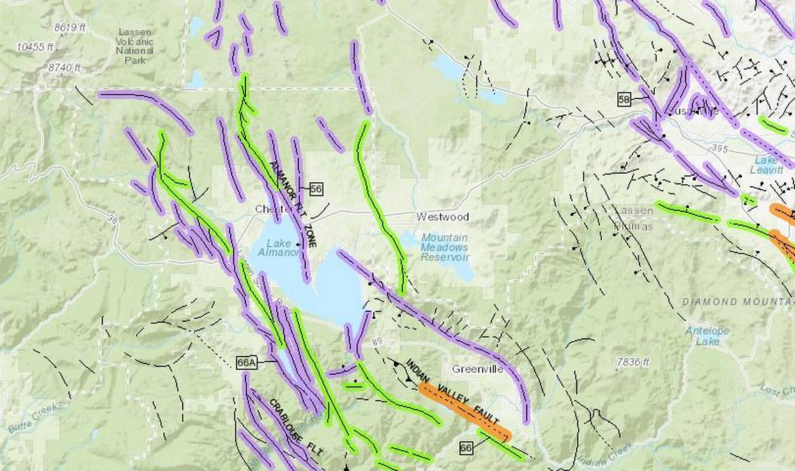

* The California Geological Survey map posted above shows faults near the Lake Almanor area in Plumas County, where a magnitude 5.5 earthquake struck on May 11th, followed by a magnitude 5.2 aftershock on May 12th, both with epicenters beneath the lake. Faults marked in purple have moved in the past 1.6 million years, in purple during the past 700,000 years and in orange during the past 11,700 years.
Banner photo of Lassen National Park © 2022 Fred Rogers, all rights reserved. Not intended for republication.
Map courtesy of the California Geological Survey.
Broken bottles photo by kind courtesy of the Plumas Pines Resort.